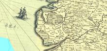
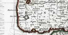
The Fylde is an area composed of boulder clay where people have lived on the higher portions where the towns/villages and farm houses were sited. Between them were areas of bog land known as mosses and woodland. Over the years these have been drained although not much drainage had taken place in 1719.
The area where St. Annes now lies was sea and sand hills were starting to form there. It was very poor farm land and was 'common land'.
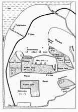
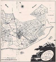
Lytham in 1720 was sparsely populated with the village concentrated around and mainly on the East side of what is now Clifton Square and Market Square and apart from Kirkham, was the largest village on the North West Side of the Ribble. The cottages were primitive, built on cruck frames, thick walls of cobble and clay, thatched and a falling step to an earth floor; peat and wood were the only fuel. The inhabitants were dependent on agriculture of a primitive nature with some inshore fishing, shrimping, gathering cockles and mussels for these were plentiful in a clean tidal estuary. There were also a few tradesmen, tailors, blacksmiths and such like although the number of inhabitants at the time was given at about 850. In 1676 a true account of every inhabitant of the Parish of Lytham is given as 261. This was witnessed by James Threlfall, minister, and four churchwardens of which only one John Gaulter could sign his name – the other three made their marks.
There were tenants, farmers, husbandmen and yeomen who enjoyed a better position than the majority of the villagers some of whom were employed by the estate. The trade of boat building on a small scale provided for those in occupation as fishermen. There had been salt refining at what is now an area at the East end of Lytham, Saltcotes, referred to in the original foundation Charter as Snartsalte.
All along the coast there were sand hills thrown up by the force of wind and tide, beaches of shingle and clean golden sand. Inland was thickly wooded with oak, beech, birch, elm and willow. Crofts in and around the village and fields stretching further inland, the field lands to become, as we know today, the area The Fylde.
There was a windmill between what is now the cricket field and Lytham Hall, the land in that area and on most maps since that period has been referred to as Mill Hill Wood and Mill Field. The hall stood almost on the present site and was occupied at the time by Thomas Clifton, Squire and Lord of the Manor.
The shore line contained a lot shingle formed from the boulders within the clay many coming from within the clay cliffs to the north of Blackpool. When these became protected to stop them being washed away the source dried up, and as we have used them as building materials most have now gone from the shore line. The sea used to pile them in banks, known as 'stanners' and we see that name on old maps. the 'double stanner' enclosed the area that is now Fairhaven lake. On some old maps 'Stanners end' appears where Lytham shipyard used to be.
On the 1812 map we can see lots of narrow fields either side of the Liggard brook and these are likely to be the ancient ridge and furrow field system which is likely to be where the ordinary folk of Lytham had their land. You can also see on that map the road out of Lytham to the east was what is now Mythop Rd going through what was Hardman's farm and across to Warton Hall and then further east down Lodge Lane. The area where the current roads are must have been subsequent to flooding and 'Lytham pool' came quite a way inland.
If you have additional information or pictures that may usefully added to this page then please get in touch with us.